Bavovna AI Hybrid INS Navigation kit
Order Delivery
Al-powered Hybrid Inertial Navigation (H-INS) for UVs under GPS-denial / EW threats
Technical specifications
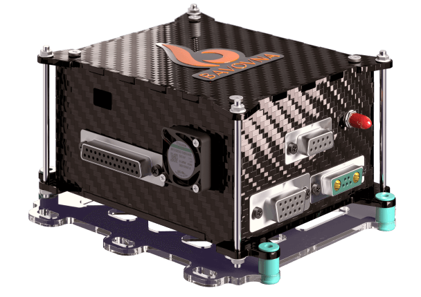
Multilayer carbon, anisotropic structure + PEI impurities. Fastening from below surface on additional dampers, for vibration isolation.
W x L x H: 150 x 134 x 73 mm
The entire system, including our IMU, Al-powered flight control and light composite enclosure, weighs only 800g, making it lightweight and easy to install on various types of UV platforms.
Standard +5V power supply
Max current consumption: 10A, peak of 12A, 50W, Voltage/rated input current: 4.1-5.7 V / 2.5 A,
Output/input power: 14 W, USB port voltage/rated input current: 4-5.7 V / 250 mA,
Servo rail input voltage: 3.3 V / 5 V
Accelerometer, Gyroscope, Compass, Barometer, Multi-vector Airflow (Bavovna H-INS also allows the input of existing onboard sensors)
Bavovna seamlessly connects to power, CAN, PWM, RF comm, GPS, optical flow, and other sensors, providing flexibility and compatibility across UV platforms
The Bavovna Mission Planner displays Bavovna as an optional Al-powered navigation system to allow mission execution through GPS-denied / EW-threatened areas while offering an advanced API and Ul based on the Ardupilot open-source platform
Bavovna uses PX Cube as an internal flight controller, ensuring reliable and accurate control of UVs. Bavovna can also output synthetic GPS coordinates directly into your platform’s existing flight controller
Bavovna’s EMI-protected case has undergone EMF resistance tests, ensuring reliability and durability in a variety of conditions.
The range of EPPE is minimal with simple trajectories, without additional maneuvers. On a sophisticated trajectory, Bavovna maintains an EPPE < 0.5% at a range of 30 km.
Bavovna H-INS-powered vehicles can be integrated with various payloads, including radio repeaters, sensors, and SIGINT RF modules, allowing various mobile ISR and engagement capabilities in aggressive EW environments
The Bavovna system does not rely on power-hungry computer vision or unreliable maps of the flight environment
Bavovna H-INS Onboarding Path
STEP 01
UV Platform Evaluation
STEP 02
Delivery of two H-INS Developer Kits
STEP 03
Integration of the Dev Kits into your UV Platform
STEP 04
~100 hours of live flight training
STEP 05
Sensor fusion, AI model training and fine-tuning
STEP 06
Verification and validation of autonomous flight
Comparison to other Non-GPS Nav Systems
Inertial Navigation Systems (INS)
Drift, biases, cumulative error of integration
Radio (eg: VOR, LORAN, TACAN)
Signal interference and propagation delays
Landmark (optical)
Environmental conditions and landmark changes
Magnetic
Distortion by ferromagnetic, electrical currents and geological formations
Bavovna Al-enhanced H-INS
Hybrid systems can be affected by the combined errors of the systems they integrate, especially if one system’s errors are not adequately compensated by others.
Using continuous ML decreases the error rate.
