


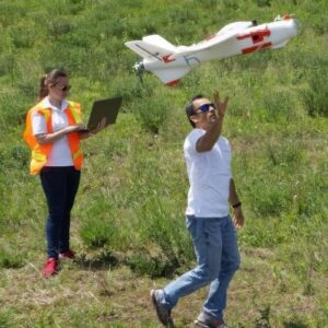


The Aeromapper Talon is the ultimate low-cost turnkey sUAS for precision data collection, mapping, and surveying.
With over 2 hours of flight endurance, a 58 km/h cruise speed, and a 30+ km data link range, it outperforms multirotor drones by mapping up to 480 hectares per flight at 1.5 cm/pixel resolution, all while delivering centimeter-level accuracy.
Equipped with a 61 MP Sony mapping camera and the Emlid Reach M2 PPK UAV Mapping Kit, the Talon ensures rapid project completion and exceptional ROI at a highly competitive price.
| Domain | professional |
| Applications | mapping, surveillance, inspection, agricultural, transport |
| Type | fixed-wing |
| Engine type | electric motor |
| Autonomy |
2 h |
| Maximum altitude |
5 km |
Ratings and reviews
0
from 5
0 reviews