


Evo Tactical
Product descripton: Evo Tactical by DeltaQuad
Aerial Intelligence
Double down on performance with dual payload capacity and extended flight range
Vertical Takeoff and Landing
Evo takes off and lands vertically in confined spaces. Automatic landing gear retraction provides 360° free field of view throughout mission execution.
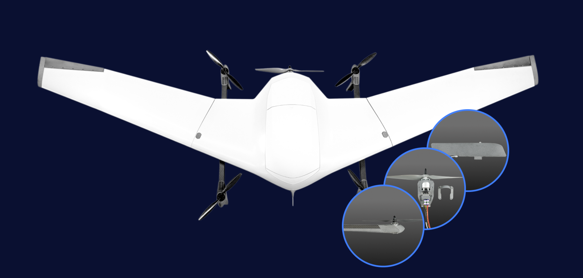
Dual Swappable Payloads
Operate two sensors simultaneously or extend flight time with an auxiliary battery. Evo’s modular payload system enables maximum insight and rapid field adaptation for a vast range of security drone sensors, automation, or customization options.
Extreme Efficiency
Patented wing design and aerodynamic performance deliver over twice the range and endurance of comparable ISR drone systems, dramatically extending operational capabilities.
User-Serviceable Design
Evo’s modular architecture enables rapid field maintenance and capability upgrades, maximizing your security drone operational readiness without factory servicing.
Battlefield-Proven
Deployed on the Ukrainian front lines, Evo Tactical excels in congested environments. Navigating safely and effectively, Evo Tactical evades constant electromagnetic interference, and offers vital support in military operations against enemy troops, returning securely upon mission completion.
Technical specifications
| Parameter | Specification |
|---|---|
| Maximum Flight Time | 244 minutes |
| Maximum Flight Range | 245 km / 152 mi |
| Maximum Radio Range | 80 km |
| Ground Control Station | Panasonic Toughbook |
| Radio Options | Silvus-IA 2.2–2.5 GHz |
| GNSS System | Anti-Jamming L1 GPS |
| ATAK Compatibility | Yes |
| Stealth Switch | Yes |
| Interference Avoidance | Yes |
| Inertial Navigation | Full inertial navigation with vision-based correction |
Engineered for the Battlefield
Evo Tactical delivers unmatched performance in high-stakes missions.
Anti-Jamming GNSS
Stay on target in contested airspaces. Resists up to 7 active GPS jammers, using a CRPA System to provide jam-free GNSS signals.
Inertial Navigation
Navigate accurately in GPS-denied environments. Uses inertial and vision-based navigation for position awareness, even during takeoff and landing.
Stealth Switch
Pre-programmable to automatically cut all radio emissions at key waypoints to execute fully autonomous stealth missions while remaining undetected.
Zero Onboard Data Storage
Critical data is never stored on board. Evo protects operators by never disclosing sensitive position or mission information, even when seized.
Interference Avoidance
Highly resistant to Electronic Warfare interference using advanced interference avoidance radio systems and highly directional data links.
ATAK Integration
Integrates ATAK standards for mesh collaboration with a vast range of military-grade ISR drone systems for insight and data sharing.
Built for Condition Resistance
Military-grade resilience to jamming, spoofing, heat, rain, snow, or winds up to 14 m/s.
-
IP54 ingress protection
-
-20°C to 45°C temperature tolerance
-
27 knots wind tolerance
Ruggedized Control with Extended Range
Equipped with a MIL-STD toughbook GCS and familiar joystick controller, Evo Tactical offers various radio and data link options. Standardized on the battlefield-proven and EW-resistant Silvus Streamcaster data link.
-
80 km Automatic Tracker
-
40 km Sector Antenna
-
15 km Omni Directional
The Intelligent ISR Drone
Evo Tactical is capable of autonomous target tracking, automatic following, high-resolution onboard recording, precise target positioning, Cursor on Target integration, and video-based position correction, up to 80 km range for single and dual operators.
-
HD recording
-
80× zoom
-
Thermal vision
Autonomous Aerial Payload Delivery
With 246 km flight range and two payload doors for two separate payload drops, Evo Tactical is the ideal ISR drone for transporting critical goods over long distances.
-
230 km maximum flight range
-
2.5 kg payload capacity
-
200 × 180 × 90 mm package dimensions
Visualize Terrain Complexities
Transform raw data into actionable intelligence. Capture detailed LiDAR scans and high-resolution RGB imagery in a single flight. Generate colorized 3D point clouds to reveal intricate terrain profiles.
-
1200 ha coverage*
-
100 data points per square meter
-
225 minutes autonomy
*These results can be achieved with YellowScan Surveyor Ultra.
Customizable at Its Core
Custom single or dual payload flexibility. 3D models and access to onboard computing included along with all the I/O optionality you will need.
-
5V & 16V power
-
MAVLink vehicle control
-
2.5 kg customization payloads