

Z-Boat 1800T
Product descripton: Z-Boat 1800T by Teledyne Marine
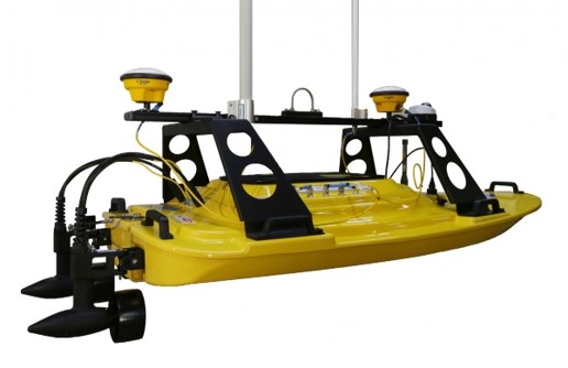
The Teledyne Oceanscience Z-Boat 1800T Trimble Edition is a high-resolution unmanned surface vehicle (USV) designed for precise shallow-water hydrographic surveying, inspection, and obstruction detection. Combining Teledyne’s advanced sonar technology with Trimble’s high-accuracy GNSS positioning and heading capabilities, the platform delivers reliable survey data in challenging and previously inaccessible environments.
Equipped with an Odom Echotrac E20 singlebeam echosounder and a Trimble BX992 dual-antenna GNSS heading receiver, the Z-Boat 1800T provides accurate depth measurements, positioning, and navigation guidance in a compact and portable package. Real-time remote data viewing allows operators to monitor missions and maintain full control throughout survey operations.
The system offers a cost-effective alternative to traditional survey vessels and hazardous diver inspections by enabling safe remote data collection from shore or difficult-access locations. Its modular sensor design allows equipment to be removed and installed on other vessels of opportunity, maximizing operational flexibility.
Designed for rapid deployment, the Z-Boat 1800T features a two-person portable configuration and a simplified single interface cable providing serial, Ethernet, and PPS connections for easy integration and operation.
Key Applications
- Shallow-water hydrographic surveys
- Real-time 2D survey and obstruction detection
- Navigation channel and harbor inspections
- Infrastructure and construction surveys
- Remote surveys in hazardous environments
- Replacement of diver-based inspection operations
Technical specifications
| Parameter | Specification |
|---|---|
| Vehicle Type | Unmanned surface vehicle (USV) |
| Primary Function | High-resolution shallow-water hydrographic surveying |
| Deployment | Two-person portable deployment |
| Survey Sensors | Odom Echotrac E20 singlebeam echosounder |
| Navigation System | Trimble BX992 dual-antenna GNSS heading receiver |
| Positioning Accuracy | RTK capable (<2 cm Z-axis accuracy) |
| GNSS Support | Multi-constellation GNSS support |
| Survey Capability | Real-time 2D survey and obstruction identification |
| Echosounder Range | Up to 1,000 m depth (with standard E20DC dual channel) |
| Data Viewing | Remote real-time data access and monitoring |
| Connectivity | Single plug-and-play cable with Serial, Ethernet, and PPS connections |
| Sensor Integration | Removable sensors for installation on other vessels of opportunity |
| Software Support | Trimble Marine Construction software |
| Deployment Advantage | Rapid mobilization, reduced survey costs, and improved operator safety |