Ryze Tello

Top Five Best Drones for Beginners

If you’re buying your first-ever drone, there are four things to consider

  1. Stabilisation features. As not yet a very experienced pilot, you’d want a gliding drone with GPS stabilization, which automatically maintains a steady flight path and minimizes drift. Models with even a basic gyroscope and accelerometer also add extra “fineness” to your flight and footage. 
  1. Safety controls like automatic return-to-home, hoover on lost signal, geo-fencing, and obstacle avoidance also reduce the odds of drone crash or loss several days after purchasing. 
  1. Battery life. The cheapest beginner drones have a flight time of 10 minutes, which is hardly enough to really enjoy the experience or hone your skills, not mention capture some decent shots. Pay some extra money for a starter drone with a 1500mAh 4S battery. 
  1. User-friendly piloting app. Spend as much time on checking out the piloting app as reviewing the drone itself. You’d want software with intuitive controls and a convenient smartphone app. The must-have features for beginners are altitude hold, headless mode, and auto-hovering. 

Here are five models that fit the above description to the dot. 
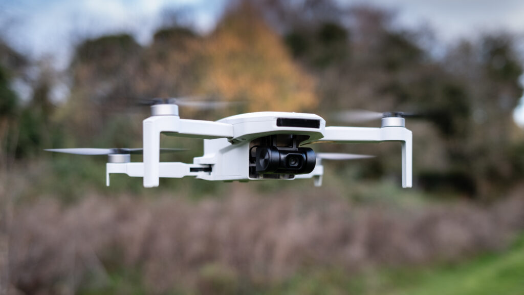
DJI NEO

DJI NEO is arguably the most affordable videography drone on the market right now, with a going price of under $200. At 135 g (4.8 oz), the drone can be flown in every country without any UAV authorization. (Although you should still maintain common sense safety rules like avoiding people overflight or cruising in restricted zones).

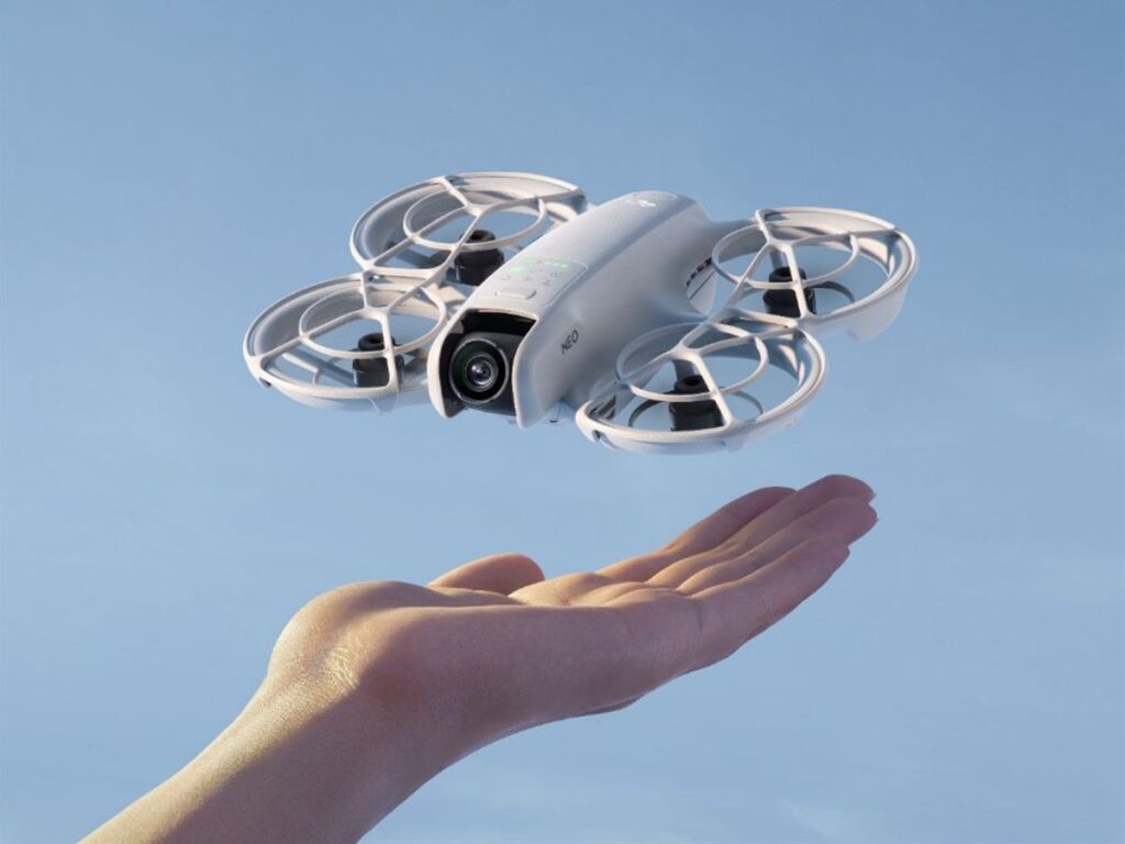
But for its tiny size, DJI NEO offers some mighty fine filming features: 4K video, 12MP stills, presets for auto-shooting from different dynamic angles, vertical video recording, and voice-activated control. 
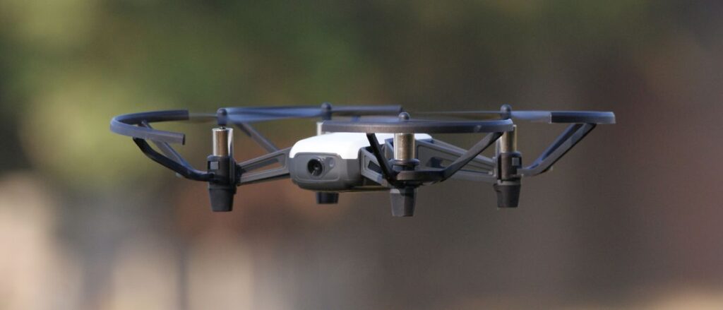
Ryze Tello 

If you’re looking for a cheap, mostly indoor beginner drone, Ryze Tello can be loads of fun. It’s ridiculously simple to control using the app and flight controller combo. And you can add FVI goggles for extra giggles if you’re training your racing skills. On the downside, the flight time is just 13 minutes and the max flight distance is 100 m/328 ft, so it’s definitely not the best drone for filming outdoorsy escapades.  


Potensic ATOM SE

Foldable ATOM SE boasts build quality. It’s sturdy, durable, but still lightweight (250 grams/8.8 ounces) to not fall under commercial drone regulations. The 4 km / 13,123 ft transmission range gives you ample room to shoot some great stills with a Sony 12MP CMOS sensor camera with a 118° FOV and a vertical +20° to -90° adjustment angle. 

ATOM SE can stay in the air for about 30 minutes at low altitudes, with no wind conditions. But the flight duration and quality drop a lot if you’re out on a windy day. 
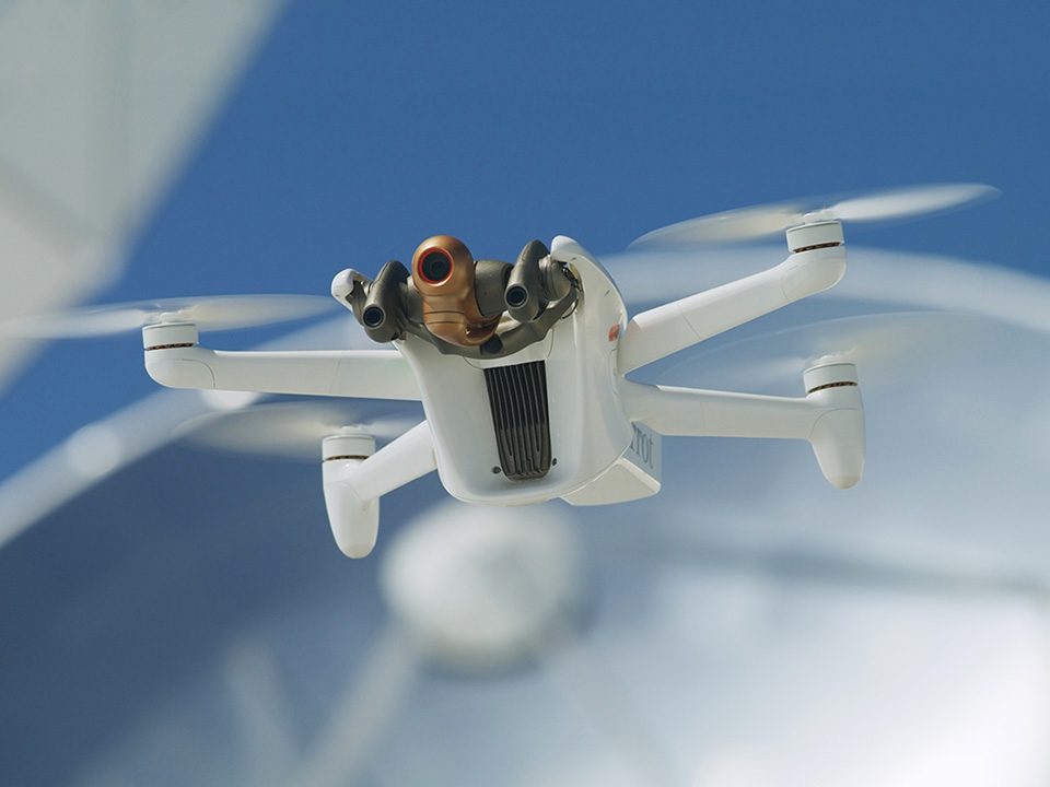

Parrot ANAFI Ai 

If you have extra cash to spare for a more professional drone, ANAFI Ai hooks you up with a roster of incredible features for autonomous photogrammetry. The 48 MP camera with a 14 EV dynamic range and 6x zoom shoots the crispest images, even at high flight speeds. 

The video is of stellar quality too: 4K video, including in P-Log and HDR10 4K videos up to 30 fps. And those planning some UAV mapping missions would appreciate specialized photogrammetry flight modes available in the drone app and 1-click flight plan creation.


HappyModel BNF Crux35

As a beginner racing drone, we can full-heartedly recommend HappyModel BNF Crux35. Retailing for under $150, the FPV drone touts an EX1404  high-efficiency motor and HQPROP 3.5-inch three-blade propeller for a robust thrust-to-weight ratio. With a 4S 850mAh battery, you’ll get about 16 minutes of flight time (but that’s all subject to how fast you choose to go). 

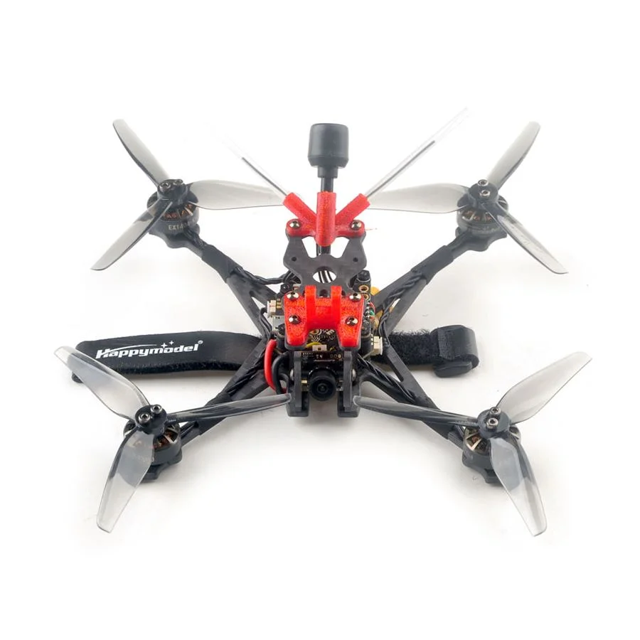
The FPV camera isn’t amazing (although you can easily replace it with a better alternative). This is a good starter racing drone that won’t hurt you too much if you crash it. 

Discover even more drone recommendations in Bavovna’s UAV directory

Remote Operated Vehicles

How Remote Operated Vehicles (ROVs) Generate Efficiency Underwater 

A remotely operated vehicle (ROV) is an autonomous, unmanned submersible used in underwater missions. Highly maneuverable, low-energy, and equipped with advanced robotics and AI, ROVs streamline underwater inspections and provide new knowledge of the global oceans. 

Here’s how remote operation vehicles make waves (pun intended) in maritime operations, the oil and gas industry, sea farming, and oceanography. 

Top 3 Remotely Operated Vehicle Use Cases 

Top-of-the-line ROVs have 4K resolution, wide lens cameras, and auto-color correction for crisp underwater imagery. Strong LED lights give visibility in murky environments. Some models may be tethered for communication with the operator, while others use AI-powered autonomous navigation.

Depending on the use case, a remotely operated vehicle can feature a robotic arm for contact manipulations, imaging sonar for 3D mapping and obstacle detection, plus onboard data processing units. 

These characteristics make the following underwater operations possible. 

Asset Inspections 

ROVs can replace divers on tedious and dangerous underwater missions. In the oil & gas industry, offshore platform operators use ROVs to inspect for structural corrosion, cracks, and other deformations. Some models also have specialized ultrasonic gauges to detect thickness loss in pipelines or rinsers or perform weld seam inspections for signs of fatigue.

Petrobras uses a fleet of ROVs to carry out inspection, maintenance, and repair of underwater equipment along the Brazilian coast. TAQA Netherlands also deployed uncrewed surface vessels for integrity inspections of shallow water infrastructure in the North Sea.

Similarly, ROVs have become the go-to tool for routine inspections in the maritime industry. Offering faster turn-around and lower costs, remote-operated vehicles can be used for hull, rudder, propeller, and anchor inspections. Norwegian Coastguard recently enlisted a Blueye Robotics’ X3 ROV to run hull inspections. 

Underwater Pipeline Surveying

Underwater pipeline leaks cost oil and gas operators millions in revenue loss and regulatory fines. ROVs can survey up to 25 km (15.5 miles) of underwater pipelines daily, helping operators manage maintenance. Specialized models with NDT tools can also detect early-stage pipe thinning for preventive strategies. And micro-ROVs can inspect pipelines from the inside through access points as small as 19-inch manholes.

Total Energies recently completed a pilot pipeline inspection program in the North Sea with Freedom AUV. The vehicle inspected over 120 km (75 miles) of submarine pipelines and 60km (37 miles) of near-shore pipelines for structural defects, with all data acquired in a single pass. 

Sustainability Initiatives 

ROVs have also become a staple in oceanography, helping scientists learn about marine life, pollution levels, and oceanic ecosystem trends. Besides data acquisition, they help drive meaningful change and offset environmental impacts.

Norwegian seafood producer Mowi increased its ROV deployments by 40% over the last year to support new initiatives for improved fish welfare. ROVs help remove dead fish from net pens, segregate jellyfish, and clean up harmful algae blooms. Thanks to the innovation, Mowi Scotland achieved a 96% superior-grade fish at harvest, while improving its animal welfare standards.

Chevron, in turn, deployed a pair of mini-ROVs — one providing visuals to the operator and the second doing the scrubbing — to clean underwater platform structures from unwanted marine growth. The compact ROV minimizes diver use and contributes to cleaner global waters.

Remote-operated vehicles also have dozens of other already feasible deployment scenarios and even more possible ones with greater adoption of AI-powered navigation systems. Some ROV use cases are currently limited by poor connectivity in the seas. At Bavovna, aim to solve this problem with AI. Compatible with both UAVs and ROVs, our INS brings the power of AI sensor fusion and autonomous navigation in GPS-denied environments. Learn more about our AI hybrid-INS system.

inertial navigation unit

How to Compensate for Drone Inertial Navigation Unit Deficiencies 

An internal navigation system (INS) provides extra situational awareness to UAVs, complementing other navigation units like GNSS, SLAM, or LIDAR-based systems. Working independently of satellites, an INS is great for countering GPS signal loss or targeted UAV jamming. But most commercial internal navigation units in drones aren’t without some critical shortcomings. 

Shortcomings of Commercial UAV Inertial Navigation Units

Most top-of-the-shelf drones are pre-furbished with internal navigation units that still require external data sources like a ground station or fusion with other sensors for autonomous navigation in GPS-denied environments. More advanced UAVs may feature better units, but they’re still susceptible to a range of issues. 

Sensitivity to Environmental Conditions 

MEMS-based inertial navigation units exhibit performance degradation under high temperatures, rapid temperature cycling, composite stress, high vibrations, and electromagnetic interference (e.g., from nearby equipment or transmission towers). High-end internal navigation systems can run smooth at a -40°C to 85°C (-40°F to 185°F) range and maintain very low bias residual errors. But they also come at a premium price tag and may not be compatible with all drone models. 

Sensor Drift 

Most INS require initial initialization and regular calibration to compensate for the inevitable drift, leading to cumulative velocity or displacement errors during flights in GPS-denied environments. 

The common types of sensor drift in drone internal navigation units include: 

  • Zero-offset (bias) drift occurs when sensor readings are inaccurate due to ongoing errors.
  • Integration drift accumulates over time due to different errors in gyroscope and accelerometer readings. 
  • Scale factor errors due to quick temperature cycling or equipment wear. 
  • Noise-induced drift (random walk) is caused by random interferences and manifests as unpredictable errors. 

Without regular recalibrations, INS errors pile up, jeopardizing autonomous flights. 

High Power Consumption

More advanced internal navigation units with ring laser gyroscopes are more power-hungry. While FOGs offer higher accuracy, even the most lightweight models consume 1.3 W against an average of 3 mA among MEMS-based systems. 

To compensate for INS drift, many companies also combine IMU readings with computer vision systems to deliver greater accuracy. With sensor fusion done on the edge, power consumption goes up massively, impeding UAV flight time. 

Using AI to Improve Inertial Navigation Unit Data Processing

INS performance can be massively improved using supervised machine learning and reinforcement learning techniques. Sensor fusion algorithms can compensate for accumulated errors and reduce noise-induced disruptions. 

Bavovna developed an AI-powered hybrid navigation kit, featuring a low-SWAP, EMI-shileded onboard unit, and a fine-tuned sensor fusion model, trained for each drone model. The entire system, including our internal navigation unit and AI-powered flight controller, weighs only 1.7lb (800gr), making it compatible with a range of UAV models. The max current consumption is 10A, preventing excessive battery drainage. 

Unlike other systems, Bavovna can maintain an ultra-long range, field-tested range of 155 miles (250km) for fully autonomous flights without any GPS reliance. The accuracy rate can be as high as 99.98%, thanks to on-edge, continuous compensation for error rates. With Bavovna hybrid INS, you can fly regular and FPV missions without worrying about signal loss, targeted interferences, or harsh temperatures. 

Learn more about our AI navigation solution for UAVs. 

Confirm that you are not a robot.